Environment
Lake Powell Water Loss Captured in Shocking New Photos
Posted on: August 24, 2022, 06:02h.
Last updated on: August 25, 2022, 01:06h.
It’s one thing to know a water body vital to life as we know it is down to 26% capacity. But it is sobering to see it in actual photos, such as the satellite images released today by NASA of parts of Lake Powell.
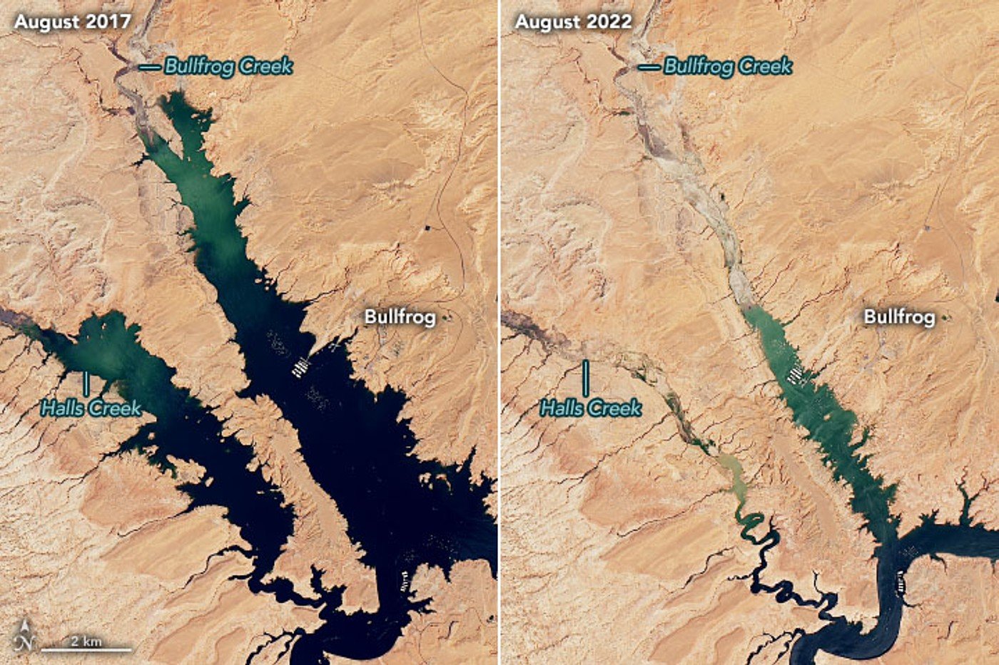
Even more sobering is the fact that the “full” photo is from 2017 when the lake was only “nearly” full at 3,633 feet. Today, Lake Powell’s water stands at 3,535 feet. That’s 98 feet lower than in 2017 and 166 feet lower than the “full pool” elevation measured in June 1980.
This is the lowest water mark for Lake Powell since it was filled in 1967, according to NASA. It is so low, it seriously endangers the production of hydroelectric power for seven U.S. states.
Lake Powell is the second-largest man-made reservoir in the US after Lake Mead. However, Lake Mead has fallen below Lake Powell in size several times this century in water volume, depth, and surface area. Sitting mostly on Utah’s southeastern border with northeastern Arizona, Lake Powell was created by the flooding of Glen Canyon by the Glen Canyon Dam, which also led to the 1972 creation of Glen Canyon National Recreation Area.
Colorado River Essential to Major US Cities
Lakes Mead and Powell are part of the Colorado River basin, providing water and electricity to 40 million people — most notably in Los Angeles, Phoenix, San Diego, and Las Vegas — and to 4 to 5 million acres of farmland in the Southwest.
Lake Powell acts as a holding tank for river outflow from the Upper Basin states (Colorado, New Mexico, Utah and Wyoming) to Lake Mead, the holding tank for the Lower Basin states (Nevada, Arizona and California).
Three years of intense drought and two decades of long-term drought in the American Southwest continue to deplete the levels of both lakes. About 86% of the land area across nine western states was affected by some level of drought, according to an Aug. 16, 2022 report from the U.S. Drought Monitor.
Future Outlooks
Hydrologists predict Lake Powell levels could drop to 3,522 feet by Jan. 1, 2023. Based on Aug. 2022 modeling projections, the US Bureau of Reclamation expects total inflows to Lake Powell to be just 62% of the average for the year. At the same time, water storage at Lake Mead on Aug. 22, 2022, stood at 28% of capacity, and the entire Colorado river system held just 34%.
On Aug. 16, 2002, federal water managers were forced to reduce the Colorado River water allotment of two states. Beginning in 2023, Arizona will receive 21% less and Nevada 8% less.
The current drought in the Western US marks the region’s driest 22-year stretch in 1,200 years, according to a study published in February 2022 in the journal Nature Climate Change.
 Most Read

Another Shooting Near Las Vegas Strip Casino Injures Man


Conversation (1 comment)